Restoration campaign of a sacred hill
 Among the efforts done by Fragas do Mandeo for preserving local nature areas, the recovery of deciduous woods on A Espenuca hill has a significant importance, as it is an emblematic site of our area. Natural, monumental and immaterial heritage do coexist there, rocks and constructions are full of legend, while erudite persons talk about a sacred hill for pre-Christian cults.
Although only its border along the River Mandeo forms part of the protected natural site SAC Betanzos-Mandeo, the hill as a whole has a great environmental and landscape value which should be efficiently protected, restoring the natural habitat in the areas degraded by the presence of exotic trees.
A land stewardship agreement
On May 5th, 2015, Fragas do Mandeo signed an agreement with the Coirós Council to manage for 50 years the municipal wood plots located in the vicinity of the protected natural heritage site. Namely, three of them are on A Espenuca hill and sum up an area of 64.195 m2.
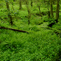
The first one is on the top of the North slope at the foot of the chapel. There are rocky and steep areas ―the cumulative elevation is 85 metres― mixed with others which are accessible thanks to a gentler slope. A eucalyptus wood was growing on this plot, occupying two thirds of the plot. It was logged by mid-2014 in order to extract the lumber; when the agreement was signed the eucalyptus had sprouted again, reaching a height higher than a person. The rest of the surface is covered by a deciduous wood with small oaks.
 The second plot is on the Southwest slope, close to the access road to the viewpoint. It is the steepest of the three, since it really is a cliff formed by granitic domes, only accessible by a track that runs by the bottom. The eucalyptus trees grow between the rocks, but also small oaks, laurels and ferns, favored by the shade. The presence of blackwood acacia is a matter of concern, because of the expansive nature of this invasive exotic species and given the difficulty of eradicating it, since a lot of shoots sprout from the roots if they are cut down. The eucalyptus trees negatively affect the landscape, since this side of the hill is visible from spots so frequented as Chelo or the main road.
The third plot is on Picoto Pequeno, name given to a promontory located on the north slope, as opposed to the top (O Picoto). This plot is adjacent to the first one and runs towards the Northeast by the most rocky and dry slope. It is densely colonized by eucalyptus and some blackwood acacia. On the bottom it switches with no transition to a deciduous wood dominated by oaks, making a type of wood named Galician-Portuguese oak wood. On its border with the river it transforms into a riparian wood considered priority habitat (91E0* Alluvial forests of alder and ash).

Although the environmental state of these plots is not good, their potential for ecological restoration is really high. A considerable portion of A Espenuca hill is covered by a really diverse deciduous wood, composed by some twenty species of native trees, with some patches of foreign species breaking the harmony. This intrusion was to a great extent spontaneous, because some of them were originally planted in this area as ornament: as early as 1950 some eucalyptus decorated the viewpoint, before the extension of its forestry exploitation.
Given that there is frequent confusion, it must be advised that the plot that borders the access road, the ones that conform the viewpoint and the plot behind the cemetery belong to the Archbishopric; the plots on the West side of the viewpoint, hiding the views of Chelo, belong to some private citizens.
Metamorphosis of the plots
In July of 2015 Fragas do Mandeo began the transformation process of these plots, beginning by the one at the foot of the chapel. The hiring of forestry professionals through external financing was necessary due to its great extension, the rugged terrain and the heavy sprouting of eucalyptus trees.
The first phase consisted on removing all the foliage left after the felling of eucalyptus trees, cutting all the new shoots and damaging the stumps in order to dry them. For this work it was necessary to use manual tools and machinery, both light and heavy, advising the workers not to move soil or rocks, because their intrinsic value and the possibility of affecting archaeological remains. It was also fixed a half a kilometre stretch of the forest track (from the road to the bifurcation Chelo-Bocelo), to facilitate the transport of the reforestation materials.

In August of that year the second phase was carried out with the help of volunteers, planting oaks and outfitting them with protection against roe deer. Thus, we reinforced the population of native trees that survived the felling, because they were too small or because they sprouted from the stumps. Remaining for a third phase was to review the eucalyptus stumps which were not yet dry and to continue reinforcing the plantation by sowing acorns, chestnuts and hazelnuts collected on the area.
In order to facilitate visits, a route that runs through the whole plot was designed, connecting interior tracks and crossing the small oak wood that already existed. An information panel which facilitates the identification of nine species of trees was installed at the start.
In 2016 the work focused on controlling the reappearance of eucalyptus, either those sprouting from stumps or those born from seed. In early May twenty four volunteers exhaustively reviewed the whole plot, before the fern size made the task too difficult. However, in the second half-year only a couple of volunteers were needed to repeat the task in two occasions.
Although the intervention in the other two plots was postponed until the required funds are available, at the end of 2016 an international field work promoted by Fragas do Mandeo and financed by the Coirós Council and the Xunta de Galicia was developed at the Picoto Pequeno. Seventeen volunteers and four instructors were clearing of scrub and cutting young eucalyptus in the most accessible side of the plot, thus starting a recovery process which is foreseen to be long because the extension of the plots, the density of the eucalyptus wood and the abrupt orography.

Rocks and legends: the mythological environment of the native forest
In A Espenuca, the lack of evidence about its past is balanced by the large number of legends about its rocks. This confers the place certain cultural interest, besides their intrinsic value as geological formations. Recovering the surrounding native forest will make the visit and viewing of the area easier, hindered until now by eucalyptus groves.
The Galician word espenuca is a synonym of cavern or cave. It comes from the Latin term spelunca, which effectively meant “cave”. But experts believe that over the years the word achieved the sense of hollow or nook (natural or artificial), it was even used as a synonym of tomb. In fact, we are still using the Galician word cova colloquially with the meaning of grave.
 The hill’s granitic nature makes difficult the existence of deep caves, but it does not impede the presence of groups of rocks that form hollows or hideouts. An example of this is the Señora rock, where the concave bottom part, made up of a number of alveoli, creates a vaulted space. Below it, the water accumulates in a bowl-shaped rock that people considered miraculous, believing it was inhabited by an enchanted lady and talking about a golden beam.
In the absence of caverns, these rocky refuges could have been used for rituals related to the cult to spirits or deities that inhabit rocks and promontories. Many rocks of the hill are named and have associated legends. Some of them have already disappeared, such as Roibal, Zoadora and one named Fémur Pétreo. But we can still visit Forno de Allares (a granitic group that forms a small cave where there are two engraved crosses), the Os Castelos rocks (so called because they are side by side in vertical position), Abaladoiro crag (which moves under the weight of a person), the Outeiro rock and Cama de Santa Eulalia (both at the foot of the bell tower), the Botilla rock (located behind this construction, it was damaged by the rehabilitation in the 80’s), A Roda and O Alxibe (it is said that romans made wheels on the first one and they kept water on the second one), O Corvo, A Cabra or O Meixón, besides the above mentioned Señora rock.
 Only few archaeological remains were discovered, since no excavation that could clarify the evolution of this enclave was undertaken. There is no evidence of a pre-Roman settlement, but a funeral stele and pieces of tegula that are found in the surroundings of the viewpoint indicate a settlement in Roman times. This conviction was born in the year 1949, when, during the construction of the access road, a hand mill and several flange tegulae were found.
The chapel’s long history
The inscription found on the Paxara rock ―destroyed around 1890 while looking for a hypothetical hidden treasure― indicated that the chapel was already built in the ninth century in honour of Saint Eulalia; this issue was also confirmed by a document of that time. But experts suspect that there had been a previous building, possibly built in the sixth century to Christianise a primitive cult site which was used as a necropolis by Romans; this construction was later destroyed during the Norman invasions of the following century. The cult to Saint Eulalia de Mérida, a martyr executed in the year 303, is one of the most ancient of Galicia, being also cited as Saint Aia, Baia or Olalla.
.") The Saint was considered protector of childbirth and fertility. This belief is linked to the ancient traditions of the lithic beds used for the fertility rites, related to the rock named Cama de Santa Eulalia (cama means “bed”). The romería (religious pilgrimage and festival) was celebrated on the Nativity of our Lady Day (September 8th) during many centuries; it was very popular in the past, but its popularity waned over time until reduced to a patronal feast.
The Saint was considered protector of childbirth and fertility. This belief is linked to the ancient traditions of the lithic beds used for the fertility rites, related to the rock named Cama de Santa Eulalia (cama means “bed”). The romería (religious pilgrimage and festival) was celebrated on the Nativity of our Lady Day (September 8th) during many centuries; it was very popular in the past, but its popularity waned over time until reduced to a patronal feast.
Cited in some documents as mosteiro de Sancta Eolalia de Spelunca, the religious community and its properties were incorporated to the Benedictine monastery of Cis in the year 1063. Thus it became a priory, until the fifteen century, when it becomes a parish. Currently the parish base is San Julián church of Coirós, located near the town hall.
The building that we can currently see has a Romanesque structure of the twelfth century, with some changes done in the fourteenth century. It was subject to an important transformation in the eighteenth century, and the current restoration of the chapel and the surrounds was done in the 1980’s. It is composed of a single nave with a rectangular apse and canon vault, but we can no more contemplate the paintings dated between 15th and 16th centuries that decorated its interior.
The bell tower, the castle and the botilla
When visiting A Espenuca one is surprised at the bell tower being separated from the chapel. Logic points to the fact that the location of this bell wall in the highest place helps the sound travel further, but it also raises the question of the chapel not having been built beside it. Experts indicate that the location of the chapel was determined by previous cults. There is a legend which solves the mystery by saying that in the mythological time of the mouros the construction was started at the top of the hill. Once the bell wall was finished, they began to erect the chapel walls, but at the following day the stones were found lower down. They placed them by the bell wall once more, but the stones changed of place again during the night. Getting tired of this curse, they decided to build the chapel on the current location and leave the bell tower where they had erected it.
.") The current bell wall was erected in the 18th century. It used to have stone steps, as can be seen in photographs of the 1920’s. It is believed that they were removed to avoid people climbing up to touch the bell inscriptions as part of a fertility rite. The original bell, dated 1693, was stolen in the sixties of the last century. Two decades later, a new one was installed, as well as the cross on the top of the bell wall. The cruceiro (granite stone cross) besides it was set up in 1985 putting together pieces taken from different places.
The current bell wall was erected in the 18th century. It used to have stone steps, as can be seen in photographs of the 1920’s. It is believed that they were removed to avoid people climbing up to touch the bell inscriptions as part of a fertility rite. The original bell, dated 1693, was stolen in the sixties of the last century. Two decades later, a new one was installed, as well as the cross on the top of the bell wall. The cruceiro (granite stone cross) besides it was set up in 1985 putting together pieces taken from different places.
Some bibliographic documents talk about the existence of a castle in the 9th and 12th centuries, which can be interpreted as a watchtower. The remains were probably used to build the chapel.
On the left of the chapel enclosure there is a botilla, local name given to a church space used as storage room or used by priests at the feast on the patron saint´s day. It already existed in the 18th century, its walls having elements as antique as a funerary stele ―decorated with a triskele– as door lintel. In the 80’s it was transformed in a small chantry holding a modern image of Our Lady, and was equipped with a Romanesque baptismal font brought from another church.
A famous viewpoint
The A Espenuca viewpoint was built by the Provincial Council of A Coruña in 1949, to take advantage of the wide scenic view from the top of the hill over the whole surrounding area. It has been a must for all visitors wanting to know our region. Now the eucalyptus that spontaneously grew at the West slope make it difficult to contemplate the spot of Chelo, declared picturesque landscape in 1972.
The geodesic vertex was installed in 1981, being established an altitude of 288.20 metres and its position in –8° 09′ 22,98” longitude and 43° 15′ 48,17” latitude (datum ETRS89, UTM 29T X = 568.467 Y= 4.790.409).
Additional information
To broaden one´s knowledge about the hill’s monuments and legends, the most complete and reliable publication is the article Espenuca: inscription, buildings and magic places, by Xosé María Veiga Ferreira and Juan Sobrino Ceballos, in Anuario Brigantino 2012, No. 35, pages 59-98.